
|
Jump to your event
Staging Area
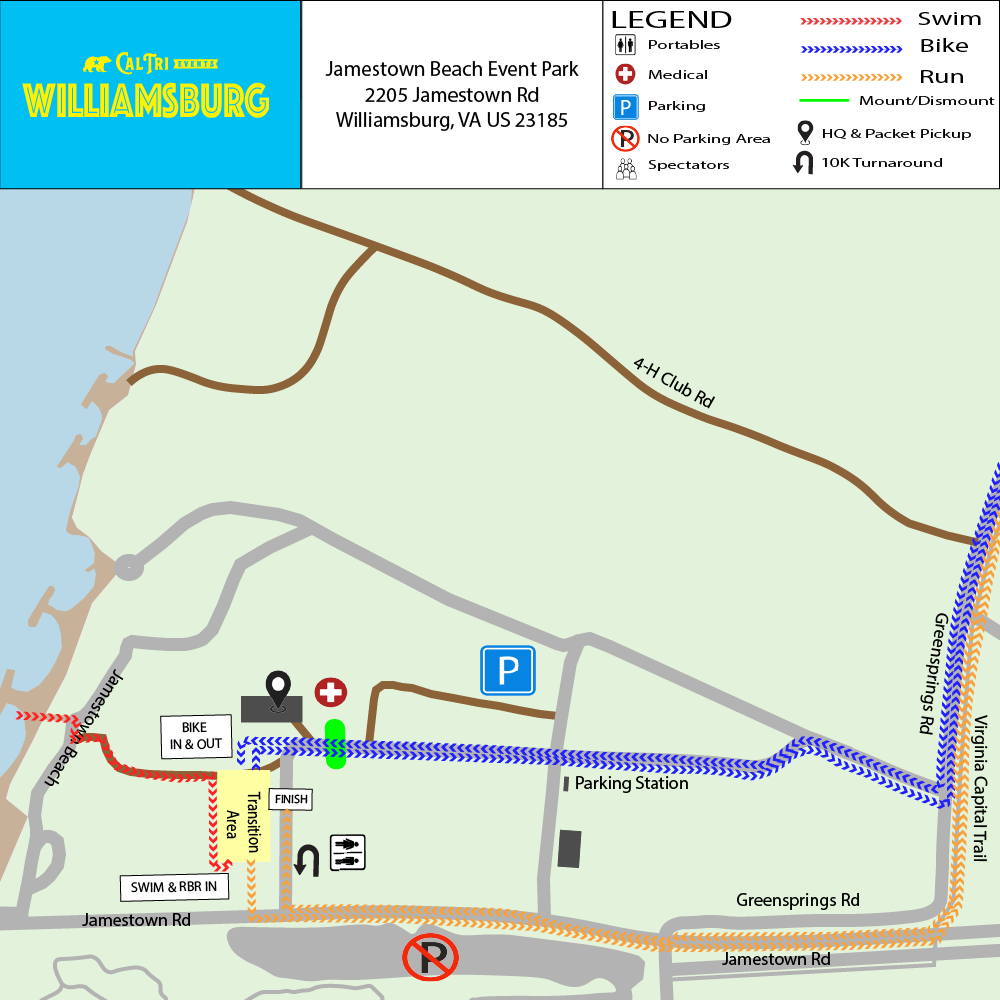
🔍 Click map to view full size in a new tab
Sprint & Youth Distance Events
🏊🚴🏃 Sprint & Youth Triathlon
|
SWIM
400
yards
|
BIKE
11.3
miles
|
RUN
3.1
miles
|
📍 Start Location: Swim Beach
|

🔍 Click map to view full size in a new tab
🚴 Sprint Bike Cue Sheet
| 0.0 mi | Start North out of transition |
| 0.2 mi | Turn right toward VA-31 N/Jamestown Rd |
| 0.3 mi | Turn left onto VA-31 N/Jamestown Rd |
| 0.4 mi | Slight right onto VA-614 E |
| 2.5 mi | Turn left onto John Tyler Hwy (VA-5) |
| 3.8 mi | Turn left to stay on John Tyler Hwy (VA-5) @ Monticello Ave (VA-5000) |
| 6.7 mi | Make a U Turn on John Tyler Hwy (VA-5) and Chickahominy Riverfront Park |
| 9.5 mi | Turn right to stay on John Tyler Hwy (VA-5) @ Monticello Ave (VA-5000) |
| 10.8 mi | Turn right onto Greensprings Rd (VA-614) |
| 12.7 mi | Turn right into Jamestown Beach Park |
| 12.8 mi | Turn left towards transition |
| 13.0 mi | Continue straight into transition |
| 13.1 mi | Dismount bike |
🏃 Sprint Run Cue Sheet
| 0.0 mi | Start South towards Jamestown Rd (VA-31) |
| 0.1 mi | Turn left onto Jamestown Rd (VA-31) |
| 0.4 mi | Turn left onto Virginia Capital Trail |
| 1.6 mi | Make a U Turn |
| 2.7 mi | Turn right onto Jamestown Rd (VA-31) |
| 3.1 mi | Turn right into Jamestown Beach Park towards the finish line |
🏃🚴🏃 Sprint & Youth RunBikeRun
|
RUN 1
3.1
miles
|
BIKE
11.3
miles
|
RUN 2
3.1
miles
|
📍 Start Location: Finish Line Arch
📌 Reading this Map
The map below shows the full triathlon course for reference. As a RunBikeRun athlete, your race uses the black bike route and red run route only. Ignore the grey swim route.
|
🔍 Click map to view full size in a new tab
🚴 Sprint Bike Cue Sheet
| 0.0 mi | Start North out of transition |
| 0.2 mi | Turn right toward VA-31 N/Jamestown Rd |
| 0.3 mi | Turn left onto VA-31 N/Jamestown Rd |
| 0.4 mi | Slight right onto VA-614 E |
| 2.5 mi | Turn left onto John Tyler Hwy (VA-5) |
| 3.8 mi | Turn left to stay on John Tyler Hwy (VA-5) @ Monticello Ave (VA-5000) |
| 6.7 mi | Make a U Turn on John Tyler Hwy (VA-5) and Chickahominy Riverfront Park |
| 9.5 mi | Turn right to stay on John Tyler Hwy (VA-5) @ Monticello Ave (VA-5000) |
| 10.8 mi | Turn right onto Greensprings Rd (VA-614) |
| 12.7 mi | Turn right into Jamestown Beach Park |
| 12.8 mi | Turn left towards transition |
| 13.0 mi | Continue straight into transition |
| 13.1 mi | Dismount bike |
🏃 Sprint Run Cue Sheet
| 0.0 mi | Start South towards Jamestown Rd (VA-31) |
| 0.1 mi | Turn left onto Jamestown Rd (VA-31) |
| 0.4 mi | Turn left onto Virginia Capital Trail |
| 1.6 mi | Make a U Turn |
| 2.7 mi | Turn right onto Jamestown Rd (VA-31) |
| 3.1 mi | Turn right into Jamestown Beach Park towards the finish line |
🏊🚴 Sprint & Youth SwimBike
|
SWIM
400
yards
|
BIKE
11.3
miles
|
📍 Start Location: Swim Beach
📌 Reading this Map
The map below shows the full triathlon course for reference. As a SwimBike athlete, your race uses the grey swim route and black bike route only. Ignore the red run route.
|
🔍 Click map to view full size in a new tab
🚴 Sprint Bike Cue Sheet
| 0.0 mi | Start North out of transition |
| 0.2 mi | Turn right toward VA-31 N/Jamestown Rd |
| 0.3 mi | Turn left onto VA-31 N/Jamestown Rd |
| 0.4 mi | Slight right onto VA-614 E |
| 2.5 mi | Turn left onto John Tyler Hwy (VA-5) |
| 3.8 mi | Turn left to stay on John Tyler Hwy (VA-5) @ Monticello Ave (VA-5000) |
| 6.7 mi | Make a U Turn on John Tyler Hwy (VA-5) and Chickahominy Riverfront Park |
| 9.5 mi | Turn right to stay on John Tyler Hwy (VA-5) @ Monticello Ave (VA-5000) |
| 10.8 mi | Turn right onto Greensprings Rd (VA-614) |
| 12.7 mi | Turn right into Jamestown Beach Park |
| 12.8 mi | Turn left towards transition |
| 13.0 mi | Continue straight into transition |
| 13.1 mi | Dismount bike |
🏊🏃 Sprint & Youth SwimRun
|
SWIM
400
yards
|
RUN
3.1
miles
|
📍 Start Location: Swim Beach
📌 Reading this Map
The map below shows the full triathlon course for reference. As a SwimRun athlete, your race uses the grey swim route and red run route only. Ignore the black bike route entirely. After your swim you go directly into the run, with no bike leg.
|
🔍 Click map to view full size in a new tab
Course Files on Ride with GPS
🏊 Swim Course🏃 Run Course
🏃 Sprint Run Cue Sheet
| 0.0 mi | Start South towards Jamestown Rd (VA-31) |
| 0.1 mi | Turn left onto Jamestown Rd (VA-31) |
| 0.4 mi | Turn left onto Virginia Capital Trail |
| 1.6 mi | Make a U Turn |
| 2.7 mi | Turn right onto Jamestown Rd (VA-31) |
| 3.1 mi | Turn right into Jamestown Beach Park towards the finish line |
🏊 Sprint Swim
|
SWIM
400
yards
|
📍 Start Location: Swim Beach
📌 Reading this Map
The map below shows the full triathlon course for reference. As a 400 Yard Swim athlete, you complete the grey swim route only. Ignore the bike and run portions of the map entirely.
🔍 Click map to view full size in a new tab
Course Files on Ride with GPS
🏊 Swim Course🏃 5K Run
|
RUN
3.1
miles
|
📍 Start Location: Finish Line Arch
📌 Reading this Map
The map below shows the full triathlon course for reference. As a 5K Run athlete, you follow the red run route only. Ignore the swim and bike portions of the map entirely.
🔍 Click map to view full size in a new tab
Course Files on Ride with GPS
🏃 Run Course🏃 Sprint Run Cue Sheet
| 0.0 mi | Start South towards Jamestown Rd (VA-31) |
| 0.1 mi | Turn left onto Jamestown Rd (VA-31) |
| 0.4 mi | Turn left onto Virginia Capital Trail |
| 1.6 mi | Make a U Turn |
| 2.7 mi | Turn right onto Jamestown Rd (VA-31) |
| 3.1 mi | Turn right into Jamestown Beach Park towards the finish line |
Olympic Distance Events
🏊🚴🏃 Olympic Triathlon
|
SWIM
1,640
yards
|
BIKE
23.4
miles
|
RUN
6.2
miles
|
📍 Start Location: Swim Beach
|

🔍 Click map to view full size in a new tab
🚴 Olympic Bike Cue Sheet
| 0.0 mi | Start North out of transition |
| 0.2 mi | Turn right toward VA-31 N/Jamestown Rd |
| 0.3 mi | Turn left onto VA-31 N/Jamestown Rd |
| 0.4 mi | Slight right onto VA-614 E |
| 2.5 mi | Turn left onto John Tyler Hwy (VA-5) |
| 3.8 mi | Turn left to stay on John Tyler Hwy (VA-5) @ Monticello Ave (VA-5000) |
| 6.7 mi | Cross Chickahominy River Bridge |
| 10.9 mi | Sharp left onto Wilcox Neck Rd (VA-623) |
| 12.5 mi | Make a U Turn on Wilcox Neck Rd (VA-623) |
| 14.0 mi | Turn right onto John Tyler Hwy (VA-5) |
| 17.7 mi | Recross Chickahominy River Bridge |
| 21.2 mi | Turn right to stay on John Tyler Hwy (VA-5) @ Monticello Ave (VA-5000) |
| 22.4 mi | Turn right onto Greensprings Rd (VA-614) |
| 24.3 mi | Turn right into Jamestown Beach Park |
| 24.4 mi | Turn left towards transition |
| 24.6 mi | Continue straight into transition |
| 24.7 mi | Dismount bike |
🏃 Olympic Run Cue Sheet
| 0.0 mi | Start South towards Jamestown Rd (VA-31) |
| 0.1 mi | Turn left onto Jamestown Rd (VA-31) |
| 0.4 mi | Turn left onto Virginia Capital Trail |
| 1.6 mi | Make a U Turn |
| 2.7 mi | Turn right onto Jamestown Rd (VA-31) |
| 3.1 mi | Make a U Turn |
| 3.5 mi | Turn left onto Virginia Capital Trail |
| 4.7 mi | Make a U Turn |
| 5.8 mi | Turn right onto Jamestown Rd (VA-31) |
| 6.2 mi | Turn right into Jamestown Beach Park towards the finish line |
🏃🚴🏃 Olympic RunBikeRun
|
RUN 1
3.1
miles
|
BIKE
23.4
miles
|
RUN 2
6.2
miles
|
📍 Start Location: Finish Line Arch
📌 Reading this Map
The map below shows the full Olympic triathlon course for reference. As an Olympic RunBikeRun athlete, your race uses the black bike route and red run route only. Ignore the grey swim route.
Run #1 is one loop of the run course before heading to the bike.
Run #1 is one loop of the run course before heading to the bike.
|
🔍 Click map to view full size in a new tab
🚴 Olympic Bike Cue Sheet
| 0.0 mi | Start North out of transition |
| 0.2 mi | Turn right toward VA-31 N/Jamestown Rd |
| 0.3 mi | Turn left onto VA-31 N/Jamestown Rd |
| 0.4 mi | Slight right onto VA-614 E |
| 2.5 mi | Turn left onto John Tyler Hwy (VA-5) |
| 3.8 mi | Turn left to stay on John Tyler Hwy (VA-5) @ Monticello Ave (VA-5000) |
| 6.7 mi | Cross Chickahominy River Bridge |
| 10.9 mi | Sharp left onto Wilcox Neck Rd (VA-623) |
| 12.5 mi | Make a U Turn on Wilcox Neck Rd (VA-623) |
| 14.0 mi | Turn right onto John Tyler Hwy (VA-5) |
| 17.7 mi | Recross Chickahominy River Bridge |
| 21.2 mi | Turn right to stay on John Tyler Hwy (VA-5) @ Monticello Ave (VA-5000) |
| 22.4 mi | Turn right onto Greensprings Rd (VA-614) |
| 24.3 mi | Turn right into Jamestown Beach Park |
| 24.4 mi | Turn left towards transition |
| 24.6 mi | Continue straight into transition |
| 24.7 mi | Dismount bike |
🏃 Olympic Run Cue Sheet
| 0.0 mi | Start South towards Jamestown Rd (VA-31) |
| 0.1 mi | Turn left onto Jamestown Rd (VA-31) |
| 0.4 mi | Turn left onto Virginia Capital Trail |
| 1.6 mi | Make a U Turn |
| 2.7 mi | Turn right onto Jamestown Rd (VA-31) |
| 3.1 mi | Make a U Turn |
| 3.5 mi | Turn left onto Virginia Capital Trail |
| 4.7 mi | Make a U Turn |
| 5.8 mi | Turn right onto Jamestown Rd (VA-31) |
| 6.2 mi | Turn right into Jamestown Beach Park towards the finish line |
🏊🚴 Olympic SwimBike
|
SWIM
1,640
yards
|
BIKE
23.4
miles
|
📍 Start Location: Swim Beach
📌 Reading this Map
The map below shows the full Olympic triathlon course for reference. As an Olympic SwimBike athlete, your race uses the grey swim route and black bike route only. Ignore the red run route.
|
🔍 Click map to view full size in a new tab
🚴 Olympic Bike Cue Sheet
| 0.0 mi | Start North out of transition |
| 0.2 mi | Turn right toward VA-31 N/Jamestown Rd |
| 0.3 mi | Turn left onto VA-31 N/Jamestown Rd |
| 0.4 mi | Slight right onto VA-614 E |
| 2.5 mi | Turn left onto John Tyler Hwy (VA-5) |
| 3.8 mi | Turn left to stay on John Tyler Hwy (VA-5) @ Monticello Ave (VA-5000) |
| 6.7 mi | Cross Chickahominy River Bridge |
| 10.9 mi | Sharp left onto Wilcox Neck Rd (VA-623) |
| 12.5 mi | Make a U Turn on Wilcox Neck Rd (VA-623) |
| 14.0 mi | Turn right onto John Tyler Hwy (VA-5) |
| 17.7 mi | Recross Chickahominy River Bridge |
| 21.2 mi | Turn right to stay on John Tyler Hwy (VA-5) @ Monticello Ave (VA-5000) |
| 22.4 mi | Turn right onto Greensprings Rd (VA-614) |
| 24.3 mi | Turn right into Jamestown Beach Park |
| 24.4 mi | Turn left towards transition |
| 24.6 mi | Continue straight into transition |
| 24.7 mi | Dismount bike |
🏊🏃 Olympic SwimRun
|
SWIM
1,640
yards
|
RUN
6.2
miles
|
📍 Start Location: Swim Beach
📌 Reading this Map
The map below shows the full Olympic triathlon course for reference. As an Olympic SwimRun athlete, your race uses the grey swim route and red run route only. Ignore the black bike route entirely. After your swim you go directly into the run, with no bike leg.
|
🔍 Click map to view full size in a new tab
Course Files on Ride with GPS
🏊 Swim Course🏃 Run Course
🏃 Olympic Run Cue Sheet
| 0.0 mi | Start South towards Jamestown Rd (VA-31) |
| 0.1 mi | Turn left onto Jamestown Rd (VA-31) |
| 0.4 mi | Turn left onto Virginia Capital Trail |
| 1.6 mi | Make a U Turn |
| 2.7 mi | Turn right onto Jamestown Rd (VA-31) |
| 3.1 mi | Make a U Turn |
| 3.5 mi | Turn left onto Virginia Capital Trail |
| 4.7 mi | Make a U Turn |
| 5.8 mi | Turn right onto Jamestown Rd (VA-31) |
| 6.2 mi | Turn right into Jamestown Beach Park towards the finish line |
🏊 Olympic Swim
|
SWIM
1,640
yards
|
📍 Start Location: Swim Beach
📌 Reading this Map
The map below shows the full Olympic triathlon course for reference. As an Olympic swim athlete, you complete the grey swim route only. Ignore the bike and run portions of the map entirely.
🔍 Click map to view full size in a new tab
Course Files on Ride with GPS
🏊 Swim Course🏃 10K Run
|
RUN
6.2
miles
|
📍 Start Location: Finish Line Arch
📌 Reading this Map
The map below shows the full Olympic triathlon course for reference. As a 10K Run athlete, you follow the red run route only. Ignore the swim and bike portions of the map entirely.
🔍 Click map to view full size in a new tab
Course Files on Ride with GPS
🏃 Run Course
🏃 Olympic Run Cue Sheet
| 0.0 mi | Start South towards Jamestown Rd (VA-31) |
| 0.1 mi | Turn left onto Jamestown Rd (VA-31) |
| 0.4 mi | Turn left onto Virginia Capital Trail |
| 1.6 mi | Make a U Turn |
| 2.7 mi | Turn right onto Jamestown Rd (VA-31) |
| 3.1 mi | Make a U Turn |
| 3.5 mi | Turn left onto Virginia Capital Trail |
| 4.7 mi | Make a U Turn |
| 5.8 mi | Turn right onto Jamestown Rd (VA-31) |
| 6.2 mi | Turn right into Jamestown Beach Park towards the finish line |